Spuren vergangener Tage
Das Kernstück der damaligen Burg war der um 1277 erstellte Wohnturm. Die Jahrringe der erhaltenen Holzbalken lassen auf dieses Baujahr schliessen. Der Turm wurde mit vier Vollgeschossen und einem Dachraum realisiert. Über den Hocheingang gelangte man ins 2. Geschoss, den Empfangsraum des Turms. Von dort erschloss sich das darunterliegende Sockelgeschoss, das als Lagerraum diente. In der Südwestecke dieses 1. Geschosses befand sich ein zusätzlicher Keller- oder Kühlraum, der ca. 2 m tief reichte.
Mittelalterlicher Wohnkomfort
Eine Innentreppe führte vom Eingangsbereich hinauf in das 3. Geschoss. Dieses Wohngeschoss war in drei Kammern unterteilt. Die Westkammer beherbergte die Küche mit Schüttstein, hölzernem Ausguss und Abort. Im Osten lagen die Aufenthaltsräume mit möglicherweise beheizter Stube und darüberliegender Schlafkammer. Herdstelle, Rauchabzug und/oder Kachelofen dürften in der Mitte des Geschosses gelegen haben, da sich an den Wänden keinerlei Russspuren finden. Die Konstruktion der aus Holz gezimmerten Ostkammern mit dem eingezogenen Zwischenboden lässt sich noch heute an den horizontalen und vertikalen Mörtelbrauen ablesen.
Wehrhafter Amtssitz mit Weitblick
Das 4. Geschoss diente wohl als Amts-, Wach- und/oder Arbeitsstube. Durch die Türöffnung in der Nordwand erreichte man die hölzerne Wehrlaube. Sie umfasste das Geschoss komplett und bot beste Übersicht. Direkt unter dem Dach befand sich der Dachraum, der sich zum Lufttrocknen und Räuchern von Lebensmitteln eignete. Die heute noch erhaltenen Zinnen umschlossen ein Satteldach, das wohl mit Steinplatten abgedeckt war.
Archäologische Grabung und Bauuntersuchung
Der Einbau der Aussichtsplattform im Turm veranlasste die Abteilung Denkmalpflege und Archäologie (Justizdirektion Uri) 2021, eine Notgrabung durchzuführen. Dabei liessen sich die bis zu 1,3 m breite Umfassungsmauer, die mit dem Turm erbaut wurde, sowie Bau-, Nutzungs- und Abbruchschichten nachweisen. Teile der Mauer und der westseitige Halsgraben sind nach wie vor ersichtlich. Hingegen sind die Lage des Holzstegs, der darüber führte, und des Burgeingangs in der Abbildung oben hypothetisch festgelegt. Der Hügelsporn wurde schon im 7. oder 8. Jahrhundert n. Chr. gerodet, wie ein verkohltes Astfragment aus der ältesten Nutzungsschicht belegt. Bereits vor dem Bau der Burganlage scheint eine gemauerte Struktur existiert zu haben. Darauf verweisen im Turmfundament verbaute Fragmente von Abbruchmörtel und eine ältere Kalkmörtelschicht. Teile der Mauer und der westseitige Halsgraben sind nach wie vor ersichtlich. Hingegen sind die Lage des Holzstegs, der darüber führte, und des Burgeingangs in der Abbildung hypothetisch festgelegt.
Traces of a bygone era
The centrepiece of the former fortress was the residential tower. The growth rings in the preserved wooden beams indicate that it was built around 1277. The tower was constructed with four full floors and an attic storey. The upper entrance led to the tower’s second-floor reception chamber, from which the basement providing storage was accessed. In the south-west corner of this first floor was an additional cellar or cold storage room, which was about two metres deep.
Mediaeval home comforts
An interior staircase led from the entrance area up to the third floor. This residential floor was divided into three chambers. The west chamber housed the kitchen, with its sink, wooden drainpipe and privy. To the east were the living quarters, possibly with a heated parlour and sleeping chamber above. The hearth, flue and/or tiled oven were probably located in the middle of the floor, as there are no traces of soot on the walls. The wooden construction of the chambers to the east, with partitioned mezzanine, can still be discerned from the horizontal and vertical ridges in the mortar today.
Fortified official residence with a view
The fourth floor was probably an office, guardroom and/or workroom. The wooden battlements were reached through the doorway in the north wall. They completely encompassed this storey and offered the best lookout. Directly under the roof was the attic, which was suitable for air-drying and smoking food. The battlements, which still exist today, were enclosed by a gable roof that was probably covered with stone slabs.
Archaeological excavation and building survey
The installation of the viewing platform in the tower prompted the Department of Monument Preservation and Archaeology (Department of Justice, Uri) to carry out an emergency excavation in 2021. Traces of the enclosure wall, built at the same time as the tower and up to 1.3 metres wide, as well as functional areas and demolished elements, were discovered in the process. Parts of the wall and the neck ditch on the west side are still visible. Conversely, the position of the wooden walkway that led over it and the castle entrance shown in the illustration above are merely hypothetical. The hilltop was cleared as long ago as the 7th or 8th century AD, as evidenced by the charred fragment of a branch found in the oldest layer of use. A stone structure appears to have existed here even before the castle was built. This is indicated by fragments of demolition mortar and an older layer of lime mortar in the tower’s foundations. Parts of the wall and the neck ditch on the west side are still visible. Conversely, the position of the wooden walkway that led over it and the castle entrance shown in the illustration above are merely hypothetical.
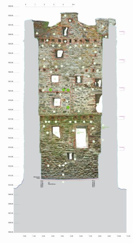
Bauarchäologischer Aufnahmeplan, hier die Innenwand Süd mit horizontaler (189) und vertikaler Mörtelbraue (21), die auf die gezimmerten Kammereinbauten verweisen. Plan: BAB Gollnick, auf Grundlage von Terradata.
Archaeological plan, here showing the southern inner wall with horizontal (189) and vertical mortar ridges (21), which are evidence of the timbered chamber installations. Plan: BAB Gollnick, based on groundwork by Terradata.
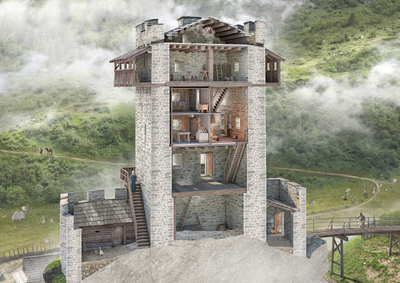
Rekonstruktion des Turminnern. Urheber: Joe Rohrer (im Auftrag der Abt. Denkmalpflege und Archäologie UR).
Reconstruction of the tower’s interior. Initiator: Joe Rohrer (on behalf of the Conservation and Archaeology Dept. of the Canton of Uri).
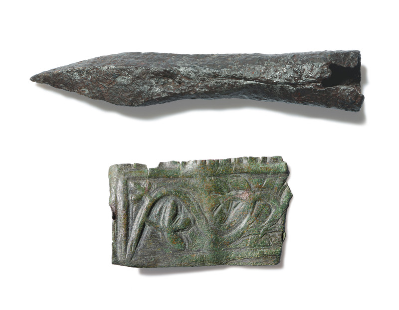
Armbrustbolzenspitze aus Eisen um 1300 (Länge 6,6 cm), gefunden im Turminnern. Pressblech-Beschlag aus Bronze mit Pflanzendekor (Länge 4,3 cm), gefunden im Burgareal. Foto: Valentin Luthiger.
Iron crossbow bolt tip from around 1300 (6.6 cm long), found inside the tower. Beaten bronze sheet with plant decoration (4.3 cm long), found in the castle precinct. Photo: Valentin Luthiger.

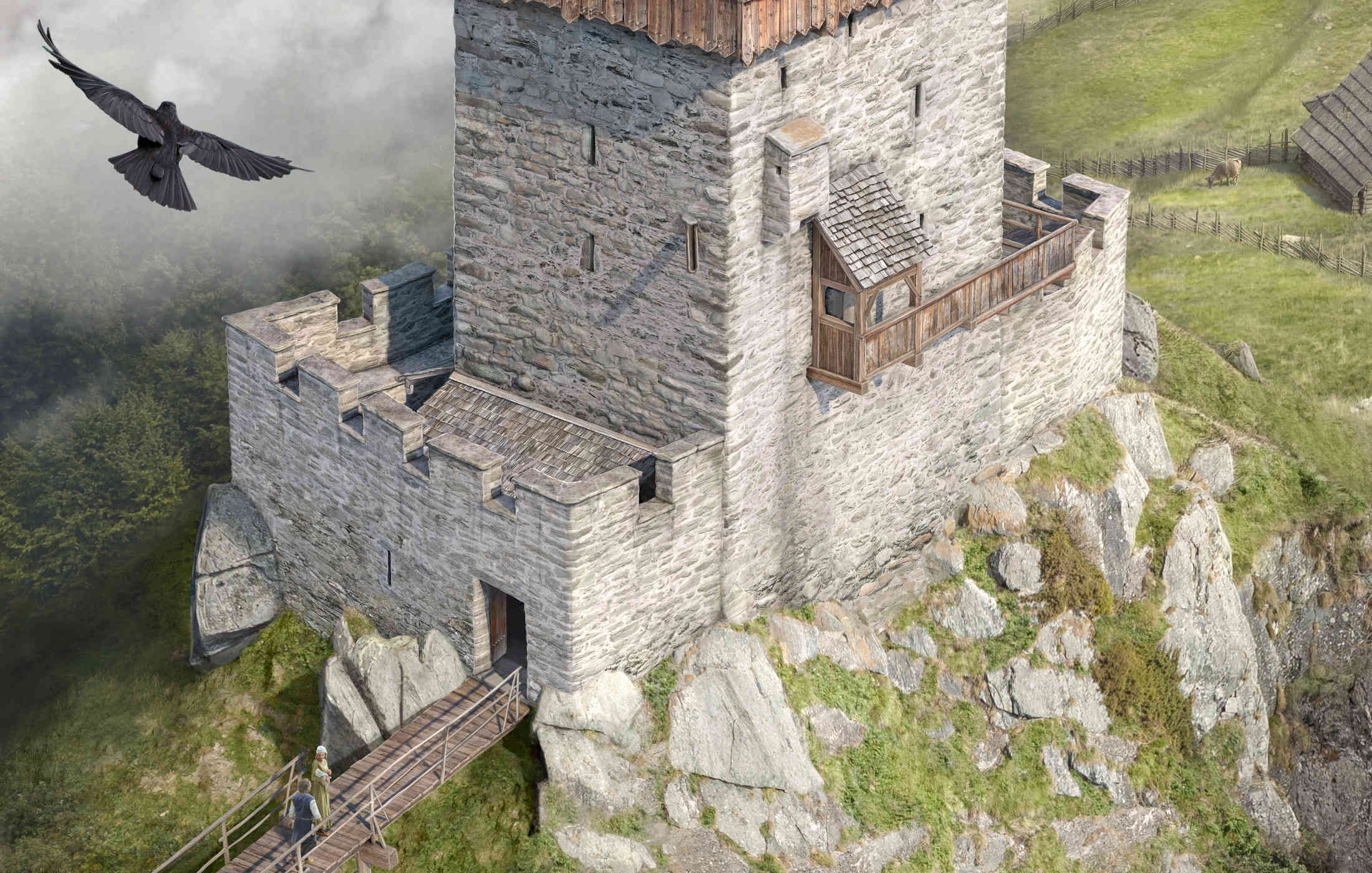
Rekonstruktion der Burganlage mit Turm und Graben gemäss aktuellem Wissensstand. Urheber: Joe Rohrer (im Auftrag der Abt. Denkmalpflege und Archäologie UR).
Reconstruction of the castle complex with tower and moat based on current information. Initiator: Joe Rohrer (on behalf of the Conservation and Archaeology Dept. of the Canton of Uri).
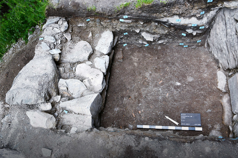
Grabungsfoto auf der Nordseite des Turms mit Umfassungsmauer und zugehöriger Nutzungsschicht. Foto: ProSpect GmbH.
Excavation photo showing the north side of the tower with enclosure wall and associated use layer. Photo: ProSpect GmbH.
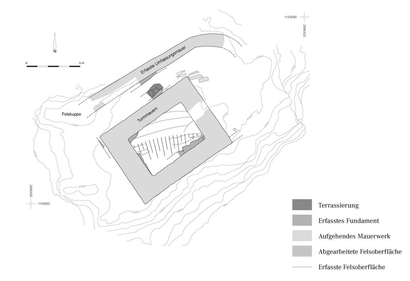
Grundriss mit archäologischen Befunden. Plan: ProSpect GmbH, auf Grundlage von Terradata.
Floor plan showing archaeological findings. Plan: ProSpect GmbH, based on groundwork by Terradata.